


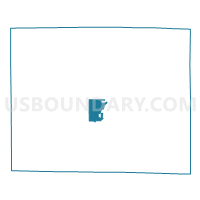
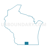
ROCK - T 3 Voting District, Rock County, Wisconsin
About
Outline

Summary
| Unique Area Identifier | 696609 |
| Name | ROCK - T 3 Voting District |
| County | Rock County |
| State | Wisconsin |
| Area (square miles) | 7.52 |
| Land Area (square miles) | 7.51 |
| Water Area (square miles) | 0.01 |
| % of Land Area | 99.88 |
| % of Water Area | 0.12 |
| Latitude of the Internal Point | 42.64815700 |
| Longtitude of the Internal Point | -89.09931670 |
Maps

Graphs
Select a template below for downloading or customizing gragh for ROCK - T 3 Voting District, Rock County, Wisconsin


Neighbors
Neighoring Voting District (by Name) Neighboring Voting District on the Map
- Janesville - C 17 Voting District, Rock County, WI
- JANESVILLE - T 1 Voting District, Rock County, WI
- JANESVILLE - T 2 Voting District, Rock County, WI
- ROCK - T 1 Voting District, Rock County, WI
- ROCK - T 7 Voting District, Rock County, WI
Top 10 Neighboring County Subdivision (by Population) Neighboring County Subdivision on the Map
- Janesville city, Rock County, WI (63,575)
- Janesville town, Rock County, WI (3,434)
- Rock town, Rock County, WI (3,196)